
Kuva Space: Rapid hyperspectral intelligence for civil security
Kuva Space delivers timely, accurate hyperspectral intelligence to support civil security, disaster response and situational awareness worldwide.
Kuva Space’s satellites are equipped with patented hyperspectral cameras that distinguish materials based on how they reflect different wavelengths of light. By capturing the unique spectral signatures of targets, Kuva Space can detect and identify changes invisible to conventional imaging systems.
This capability reveals anomalies and risks that traditional optical or radar imagery may miss. Combined with advanced processing, AI analytics, and rapid data delivery, Kuva Space provides actionable insights and alerts when they matter most, supporting authorities and first responders in protecting lives, infrastructure, and the environment.
A European pioneer in hyperspectral space technology
Founded in 2016 in Espoo, Finland, Kuva Space is one of Europe’s leading new-space companies specialising in hyperspectral Earth observation. With a proven track record in nanosatellite technologies, the company’s global Earth observation solution integrates three core technologies:
Proprietary microsatellite platform – Hyperfield
Kuva Space designs and manufactures its compact microsatellites entirely in-house. The first two hyperspectral satellites, Hyperfield-1A and Hyperfield-1B, were launched in June 2024 and August 2025 and are fully operational. These two first-generation LEO satellites are flying at 500 km, capturing images used to develop the in-house processing chain and analytics models, and executing strategic customer pilots in security, agriculture, and environmental domains.
The second-generation satellites, Hyperfield-2s, accommodate more advanced technologies, e.g., onboard GPUs, AIS receivers, Sat-to-Sat transreceivers, and 3 m VHR optical. Hyperfield 2 is in development, with the first launches planned for late 2026 and 2027, and will be flying at VLEO.
Kuva Space aims to grow its constellation to 100 satellites by 2030, enabling multiple daily revisits anywhere on Earth to provide always-on monitoring and decision-ready insights to its customers.
Patented hyperspectral imaging
Kuva Space satellites carry patented hyperspectral cameras based on tunable Fabry–Perot interferometers. Unlike traditional cameras that capture only three colour bands, or radar systems that only provide information on textures, Kuva Space imagers record up to 160 narrow spectral bands, distinguishing materials and types at the biochemical level.
Each material reflects and absorbs light differently across the electromagnetic spectrum. Kuva Space captures these spectral fingerprints from space, enabling precise identification and monitoring of objects and environments.
- First-generation satellites operate in the visible and near-infrared range (475–950 nm).
- Second-generation satellites will extend coverage into the short-wave infrared (450-1650 nm), unlocking even more applications.
Advanced AI-powered analytics
Incoming hyperspectral data is automatically transformed into intelligence using Kuva Space’s AI models on board and on the ground. Raw satellite data is pre-processed with an AI-driven processing chain before advanced AI algorithms automatically detect features, classify materials, and generate alerts.
Kuva Space onboard models detect and identify changes, such as dark and stealth vessels, wildfires, landslides, terrain changes, and camouflaged targets, enabling information processing in minutes rather than hours or days.
These insights are delivered through Kuva Sense, its insights-as-a-service platform, which provides customers with continuous monitoring and decision-ready information without requiring in-house hyperspectral or data science expertise.

Hyperspectral situational awareness for civil security
As part of the Smart-Connect project Kuva Space is developing and demonstrating unique hyperspectral situational awareness alerts and fast information delivery for civil security. The three-year R&D project focuses on enabling faster, more reliable access to critical information during emergencies.
Using proprietary hyperspectral data and in-house AI-driven analytics, Kuva Space detects and identifies new vessel classes, stealth coatings, and changes in environmental conditions, such as vegetation and soil characteristics that make areas prone to wildfires, among other critical applications.
Kuva Space processes data directly onboard satellites to reduce the amount of data that must be downlinked, lower bandwidth requirements, and shorten response times. In addition to rapid onboard processing of hyperspectral data, Kuva Space will enable satellite-to-satellite (Sat-to-Sat) and satellite-to-IoT communications for its Hyperfield constellation.
Once data acquisition is processed onboard, insights or alerts can be delivered via Kuva Space’s intelligence platform or via API to the Smart-Connect or rapid responder platforms. Integration of Kuva Space intelligence with Smart-Connect’s conneXstream middleware ensures alerts and data are delivered quickly and reliably, an essential capability during crisis response.
In maritime situational awareness, Kuva Space is building a global vessel spectral library that continuously updates as Hyperfield data is captured. Each new detection expands the library, allowing AI models to continuously evolve, rediscover vessels, identify stealth coatings, and detect environmental conditions that increase wildfire or landslide risk. The result is clear, actionable alerts that help emergency teams act immediately.
Field demonstrations
Maritime border surveillance
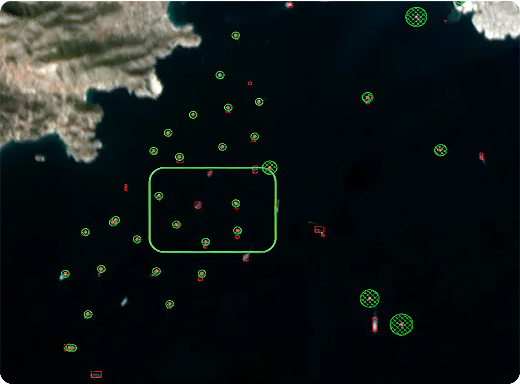
In cooperation with Finnish authorities and partners in Belgium, Kuva Space will demonstrate hyperspectral border surveillance over the Baltic Sea and the North Sea. Satellites will automatically detect marine vessels and trigger alerts when ships are operating without AIS signals, a common tactic used in smuggling and other illicit activities.
Alerts include precise coordinates, enabling rapid intervention. The vessel’s spectral signature is stored for future identification, enhancing long-term maritime domain awareness.
Critical infrastructure protection in the Arctic
A second field study focuses on protecting critical infrastructure in Arctic conditions. Kuva Space is developing AI models capable of identifying anomalies and environmental changes over snow and ice.
After selecting strategic targets, satellites will collect hyperspectral data and deliver change-detection alerts rapidly. Sat-to-Sat communications significantly reduce latency by relaying data between satellites, while Sat-to-IoT links allow low-data-rate alerts to be sent directly to responders’ handheld devices.
Unlocking new civil-security applications
Hyperspectral data enables the detection of critical targets that lack obvious visual cues, opening entirely new possibilities for civil-security operations.
Applications include:
Border monitoring: Detection of disturbed soil, construction materials, or camouflaged equipment linked to unauthorised crossings or sabotage.
Wildfire and landslide monitoring: Identification of vegetation stress, moisture levels, and soil changes to support prevention, response, and damage assessment.
Pollution and hazardous material detection: Rapid identification of oil spills, methane leaks, and industrial discharges to minimise environmental and human impact.
Critical infrastructure monitoring: Detection of anomalies around pipelines, power plants, and transport corridors, complementing ground-based inspections.
Hyperspectral data can also be combined with SAR and high-resolution optical imagery to improve reliability in all weather and lighting conditions, providing responders with a comprehensive operational picture.
Advancing civil security through space
Kuva Space’s contribution to Smart-Connect demonstrates how cutting-edge space and AI technology can strengthen civil security. By enabling material-based detection and rapid, resilient data delivery, Kuva Space fills a critical gap in today’s monitoring and surveillance systems.
Through onboard processing, Sat-to-Sat communications, and seamless platform integration, Kuva Space ensures that actionable intelligence reaches first responders when every minute counts, helping protect lives, infrastructure, and the environment.